Pages

Showing posts with label Thence I Went. Show all posts

28 July 2014

Thence I Went...Under Ground

On her 1697 tour of northern England Celia Fiennes visited landmarks rightly considered to be (and cannily marketed as) "great wonders". One such were the underground caverns called Poole's Hole, now known as  Poole's Cavern. It was a tourist attraction as early as 1622 and widely written about over the next few centuries (but I noticed Celia's account is scandalously omitted from the website's Literary Heritage page - for shame!).

No wonder that I thought of her when I visited the Luray Caverns, 'a subterranean world of wonder' right here in northern Virginia.

Limestone and mineral rock formations in Luray Caverns

Celia described her visit to Poole and the sights within the cavern:

"Just at the Entrance you must Creep, but presently you stand upright, its Roofe being very Lofty all arched in the Rocks and sound with a great Ecchoe. The Rocks are Continually dropping water all about, you pass over Loose stones and Craggy Rocks. The dripping of the water wears impression on the Stones that forms them into Severall Shapes"

The Luray Caverns were discovered in 1878 but are estimated to be 5 million years older than Celia's caves at Poole. Thanks to a good bit of engineering over the last century modern visitors don't have to 'Creep', you descend into the caverns via a sturdy staircase with signs urging, "Please Use the Hand Rails!" and penetrate into the depths along a bricked path lit with electric lights. I kept wondering what it was like for Celia, having to crawl into the cave (so unladylike, and in a fitted bodice and stays - so uncomfortable!) with no illumination on the path but the light of some candles in a lantern carried by a guide.

Pillars reaching more than 20 feet high
Like Poole's Hole, the cave rooms and some of the formations at Luray have names - all exceedingly fitting: Saracens Tent, Giant's Hall, Dream Lake, Pluto's Ghost, and Titania's Veil. There's even one monolithic formation affectionately called The Shaggy Dog. It's only 7 million years old; a mere blip in the grand scheme of geological formation.

The Shaggy Dog, largest formation in the caverns at approximately 7 million years in the making. At over 40 feet in height, standing before it makes you feel very small, in more ways than one.
Celia's friend and contemporary Daniel Defoe published his three volume A Tour Thro' The Whole Island of Great Britain, Divided into Circuits or Journies between 1724 and 1727. I often wonder if his travels weren't inspired by Celia's tales of her own. I enjoy comparing the two accounts, especially their descriptions of how the caves must have been formed, which I share here with you along with my own:

Celia Fiennes, 1697: "but the difficulty appears as to this hole how so large a Cavity should be Left, as in some places the Roofe is as lofty as you can see and all stone; now how it should be fixt so as not to tumble in by the weight of the Earth or stone on the top: as to the waters dropping it is but what is Customary among rocks and stones, there are many springs which run in the veines of the Earth and allwayes are running in such subteraneus vaults in the Earth, which gather together and runns in a little Channell in the bottom of this Cave"

Daniel Defoe, c. 1724: "It is a great cave, or natural vault, ancient doubtless as the mountain itself, and occasioned by the fortuitous position of the rocks at the creation of all things, or perhaps at the great absorption or influx of the surface into the abyss at the great rupture of the earth's crust or shell."

Deb Wiles, 2014: "Water plus Time equals THAT!? Woooooooaaaaaahhhhhhhhh!!!!!! "

Yeah, whoever finds my travel diary 300 years from now might be a wee bit disappointed.


I do have two advantages over Ms. Fiennes and Mr. Defoe, though. Namely 300 years of scientific advancement in geology and a little tool called Google. Like those at Poole, Luray's caverns are "solution caves", meaning a solution of calcium carbonate donates some of its carbon dioxide, allowing a precipitate of lime to form. The limestone which is formed by this precipitate grows at the supersonic rate of approximately one inch every 120 years. Highly acidic water once filled the chambers and ate away the softer material. As the natural water table declined, the chambers drained leaving the eroded forms behind, which are still growing. There are still springs in the caves and a constant drip in places due to surface water percolating down into the caverns. Our guide called these drips "cavern kisses" and claimed each 'kiss' brought 100 years of good luck. I should be set for the next four centuries. I suspect if the dripping at Poole's Hole had such a catchy nick name Celia would have mentioned it but all she says is:

"The dripping of the water wears impression on ye Stones that forms them into Severall Shapes, there is one Looks Like a Lyon wth a Crown on his head, ye water trickling on it weares it into so many shapes; another place Lookes just Like ye shape of a Large organ wth ye severall Keys and pipes one above another as you see in a great Cathedrall;"

I wonder if Leland W. Sprinkle had read Celia's diary when he set about creating the Great Stalacpipe Organ at Luray? It's the largest musical instrument in the world, and took three years to build starting in 1956. Sprinkle reputedly got the idea when touring the caves with his son, who hit his head on a stalactite producing a musical tone. He painstakingly located and shaved thirty-seven naturally formed stalactites to get the right notes, connecting each one to a solenoid and small rubber mallet controlled by a traditional organ console. The caves cover 64 acres and while the selected stalactites are spread around only 3.5 acres within the caves, the sound can be heard anywhere in those 64 acres. It really is an amazing feat of science and musical engineering, and I found myself wishing again for that TARDIS so I could see the look on Celia's face when she heard this:


There is also an underground lake called the Dream Lake. Fed by a spring, the lake is only 20 inches deep but very wide. The water is crystal clear and the still surface creates a perfect mirror reflecting the ceiling above so that it looks as if stalagmites are growing up beneath the water from the lake bed. The photos don't do it justice, and a collective awestruck "Ahhhhh!" came from everyone in the tour group.


Mirrored reflection of the ceiling in the still crystal water of Dream Lake
Different minerals lend their colors to the rocks as well, from brown to red to alabaster white.

The range of colors and intricate layers in this formation can be clearly seen thanks to the lighting


The formations that really awed me were the curtains, or veils. Their delicate waves look like they were carved by a master sculptor (well, I guess one could argue they were) yet each fold took millions of years to form. Mind. Blown.

Part of Saracens Tent, one of the most well formed draperies in the world.


And while Celia noted the formation at Poole that looked like 'a salted flitch of Bacon', Luray's got the fried eggs to go with it:


I still intend to visit Poole's Cavern to see what Celia saw, and I have to admit I'll be a bit disappointed if I don't have to crawl through the entrance as she did, but I love the fact that these wonders exist all over the world and that some can be so similar. Take away the modern amenities and I bet my visit to Luray Caverns wasn't really all that different from Celia's to Poole's Hole. She was a bit of a rebel, though, and broke off pieces of rock as souvenirs. This practice is Frowned Upon and visitors are admonished not to touch the rocks at Luray so I had to content myself with a free piece of Unakite from the museum which my entry ticket entitled me to.

Fitz enjoyed the American version of traveling under ground

Luray Caverns are located in Luray, VA in the Shenandoah Valley. For visiting information go to their website. Guided tours last about an hour. Tip of the day: if you go on a weekend, plan to go early and beat the crowds!

27 February 2012

Holywell House

Last weekend I officially began a pilgrimage to retrace the steps (or should I say hoof prints?) of Celia Fiennes. Researching her travels has been, oh, let's face it, a royal blast, especially for someone so hard bitten by the travel bug. Trying to find the country houses and landmarks she talks of has lead me to some interesting places, albeit restricted to libraries and the internet. Until two days ago!

But first, a bit of background.

Once upon a time this scepter'd isle was positively riddled with great country houses, those venerable piles which served as the 'country seate' of the greatest noble families and fortunate merchants with enough cash to score a piece of land. Full of visions and ideas from their Grand Tour through Italy and Europe, young nobles educated in art and architecture returned and planned the changes, additions, or new houses they would build when the old man kicked off and they finally came into their inheritance. Inspired by the concept of the Italian villa - a house in the country - stately homes began popping up in the English countryside, with building works peaking between the late 17th and mid-18th centuries. Did I mention they also had spectacular gardens?

Many of these houses, along with their gardens, were remodeled through the centuries in the latest style - Palladian, Gothic, Victorian - and some were completely pulled down and built anew. Fast forward a few hundred years to the post-WW2 era when so many of these houses were knocked down it would make you run to your bed and bite your pillow. Things started getting bad after WW1 (if you follow Downton Abbey, and I highly recommend that you do, you'll have an idea what it was like), but progressed rapidly to worse after WW2. If the house wasn't destroyed by a doodlebug, chances are many of the male staff and heirs were lost in fighting, leaving no one to continue running the estate. The cost of keeping such a place going, with hundreds of staff, became difficult, for some, impossible.

Some sources say that by the 1950s a country house was being demolished every five days, with as many as 1,200 lost since 1900. I hope you have your pillow handy. There is some good news, though. Not all met their doom by the blow of a wrecking ball. Some of them burned down! One that I was trying to find was set to be donated to the National Trust when the flame from a torch being used to remove paint from a windowsill ignited the whole house and poof! The story goes the owner was inconsolable (pillow, please).

Well, now on to my story. One such house that no longer exists is Holywell House in St. Albans. Celia Fiennes visited St. Albans and writes briefly:

"Thence to St. Albans and so we enter Hartfordshire 12 mile: there is a very large streete to the Market place, its a pretty large town takeing all, the St Juliers [St Julians] and that at one end and the other end is St Nicholas [error?? - she would have passed close to St Michaels], where is a handsome church; the great Church which is dedicated to St. Albans is much out of repaire; I see the places in the pavement that was worn like holes for kneeling by the devotes of the Religion, and his votery's, as they tell you, but the whole Church is so worn away that it mourns for some charitable person to help repaire it; there are several good houses about the town one [Holywell House] of the Earl of Maulberoug [Marlborough] and one of Mrs Gennings [Jennings] the Countess Mother."

I'm sure she'd be happy to know that the great Church has been restored, and I'll write about that later. But what about Holywell House?  I put on my deerstalker, grabbed my pipe (not really, my parents read this after all), my magnifying glass and set to work. Here's what I found:

As with any journey, we begin with a map.

st-albans-1808-chasmith

This is from Charles Smith's map of Hertfordshire circa 1808. You can clearly see St. Julians, St. Michaels, and the church of St. Albans, which Celia Fiennes mentions. Near the center of the image, just above the river, you see the location of 'Halloway House'. This is likely a corruption of the spelling 'Hallywell' which is a corruption of 'Holywell', which is the name of the road which takes its name from the holy well* located nearby. Close enough for jazz, I thought. Armed with that bit of info, I googled my way to this:

holywell-house-1806
Holywell House c. 1806 (wikicommons)

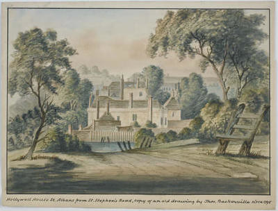
Nice place. And I can't be sure but that's probably the bell tower at St. Albans in the distance. So, knowing that the house was called Holywell House and it was located downhill from the abbey, presumably on Holywell Road, I felt pretty confident I was getting hotter. Then this came along:

Hollywell-House_-St-Albans_-from-St-Stephens-Road_-copy-of-an-old-drawing-by-Thomas-Baskerville_-circa1795_1_museumimage
Holywell House, St. Albans from St. Stephens Road, copy of a drawing by Thos. Baskerville circa 1795
(St. Albans Museum)

This excited me even more because this is probably pretty close to the view Celia Fiennes would have seen! Psych!
Next I found this:

st-albans-cotton-mill Holywell House
From a map c. 1822 produced for Clutterbuck's The History of the County of Hertford

Very promising. Even though there isn't much detail in the planted areas of the gardens, it shows the extent of the grounds and their general style, which appear to be firmly in the English Landscape era of design, a style perfected and capably marketed by Capability Brown (which makes him responsible for the disappearances of all the gardens I'm studying, the villain!).

Drawing satisfactorily on my imaginary pipe, I then consulted the Ordinance Survey maps of the 1880's:

Holywell House 1880 OS
Click to embiggen

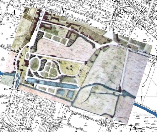
Scroll down the larger image and you'll find the location of Holywell House, along with the site of the holy well. Notice the lovely crescent with townhouses just across the street on the west side. Now for the magic:

overlay detail_edited-1

How do you like them apples!? I was curious about one thing, though. The OS map clearly shows the footprint of the house on the east side of the road while the painting clearly shows it otherwise, and since scale is always an issue with this kind of overlay (note that the bottom right corner of the painting doesn't align with the path of the river but clearly that's what it is), I wondered. Definitely a two-pipe problem. So I did what Sherlock would have done and consulted Watson (aka my tutor). Before he could respond I found this excerpt on-line from A History of the County of Hertford: volume 2 edited by William Page in 1908, detailing the residences and residents of Holywell Hill Road:

"...and Torrington House (Mr. A. F. Phillips), which last is on a part of the site of Holywell House, the seat of the Rowlatts and afterwards of the Jennings family, demolished in 1827. Sarah duchess of Marlborough was probably born here, and she and the celebrated duke occasionally lived at this house...(blah blah about a lady entomologist who lived at Torrington House)...At this point it may be noticed that a side road curves off to the west and meets the main road again a little lower down. This diversion was caused by an extension of the grounds of Holywell House into the roadway. The road, however, was reinstated in its direct course when Holywell House was pulled down."

Thank you, Mr. Page!!!

While I haven't (yet) visited the local museum, library, or archives to see if any plans or maps of the gardens at Holywell House exist, at least we have confirmed the location of the house, it's appearance near the time that Celia Fiennes would have seen it, and the design of the gardens in the mid-19th century.

And people thing garden history is boring!

So that's it. My quest has officially begun, and however long it takes, I'm going to track down each and every great house that Celia mentions. Some are easy and the grounds so extensive one could wander happily for days (think Chatsworth). Others have proven to be much more elusive but no less intriguing, especially when plans and paintings show what stateliness once existed.


195
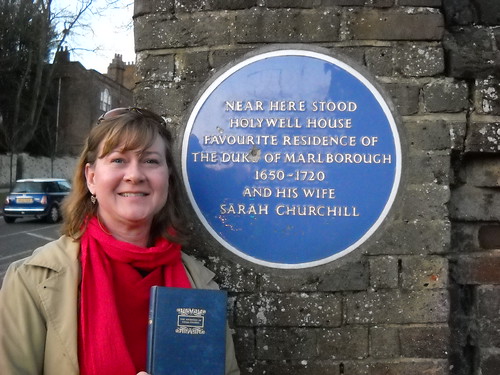
Me (and Celia) near the spot where Holywell House once stood
A special note of thanks to Louise, University of Greenwich chaplain who arranged the student pilgrimage to St. Albans (more on that next time). She graciously stalked the road with me in search of the elusive Blue Plaque and spotted it! It was on the uphill side of the wall; walking down hill, we nearly missed it.


*Legend has it that Holywell Hill Road takes its name from the holy well located nearby. When the martyr St. Albans was beheaded it was said that his head rolled down the hill and fell into the well, thus rendering it holy. Another account has it that the well sprang up on the spot at which his head stopped.